The SR-18 Scenic Byway Coalition is proposing that Utah State Route 18, from Milepost 3, starting at the Chuckwalla Trailhead at the north of St. George, UT to Milepost 40 at Enterprise be considered as a State of Utah Scenic Byway. The landscape through which Utah State Route 18 winds sits atop and within some of the most unique geological features in the world, and encompassing some of the most bio-diverse ecosystems in the entire state of Utah. The area is both visually stunning and environmentally significant.
The SR-18 Scenic Resource Coalition is a grassroots organization focused on conserving public lands adjacent to SR-18 for the benefit of future generations. These lands have tremendous educational, environmental, recreational, tourism, and rural-agrarian value, while serving as recharge zones for aquifers vital to Southwestern Washington County and the State of Utah.
Attractions Along SR-18
Highway Mile Markers and attractions as traveling from St. George North to Enterprise, Utah. Mile Markers are approximate.
Mile Marker 4
Chuckwalla Trail
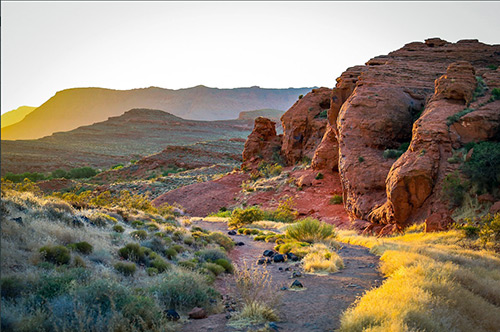
(Chuckwalla Trail Head off SR-18)
Located in the Paradise Canyon area, Chuckwalla is a major link for trails like Turtle Wall, Beck Hill, Paradise Rim, Halfway Wash, The Gap, and Gecko. The path is mostly dirt with some sand and is well marked. Chuckwalla offers beautiful scenery and features a variety of wildlife making it very family and dog friendly. Hikers, rock climbers, horseback riders and cyclists enjoy exploring the trail’s unique rock formations as well as connecting with other trails that expand into the area. Desert tortoises, rabbits, eagles, and other wildlife are often spotted along the path. Chuckwalla is a great trail that takes users right into nature.
Mile Marker 6
Unmarked Trailhead For Rock Climbers

(Rock Climbing)
Rock climbers park in this area along SR-18 to hike a short distance to rock climb. Multiple rock climbing venues along this section bordering SR-18 include: Trad, Sport, TR, and Boulder climbing.
Mile Marker 7
U.S. Flag Hill
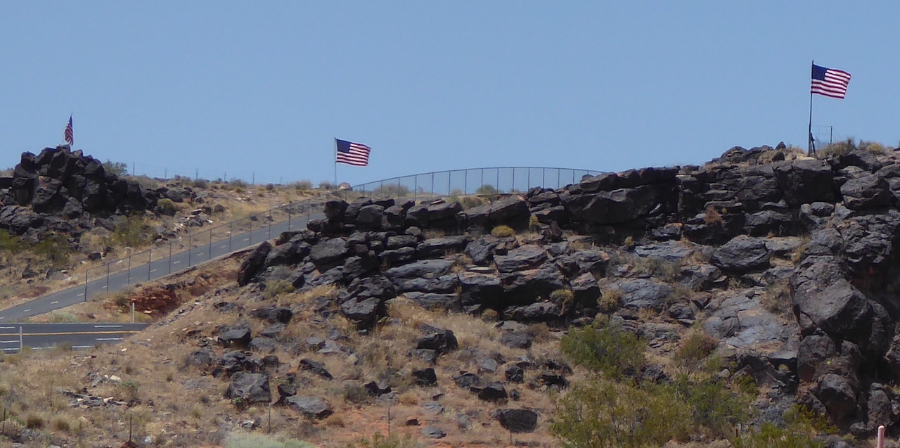
(US Flags - Both Sides of SR-18)
Mile Marker 8
Snow Canyon Petroglyphs
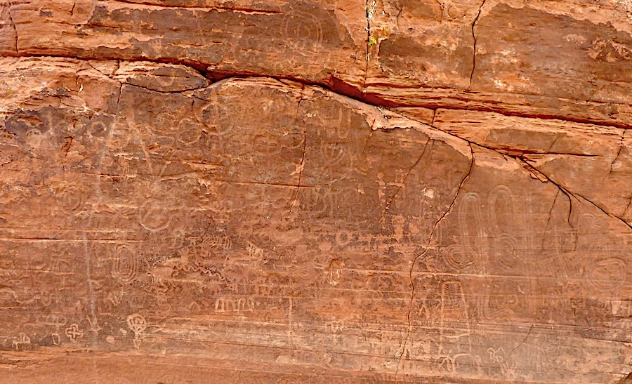
(Petroglyphs)
Widened SR-18 highway parking leading to trails into the Eastern part of Snow Canyon for petroglyph viewing. Hike in from SR-18.
Mile Marker 10
Snow Canyon Scenic Overlook
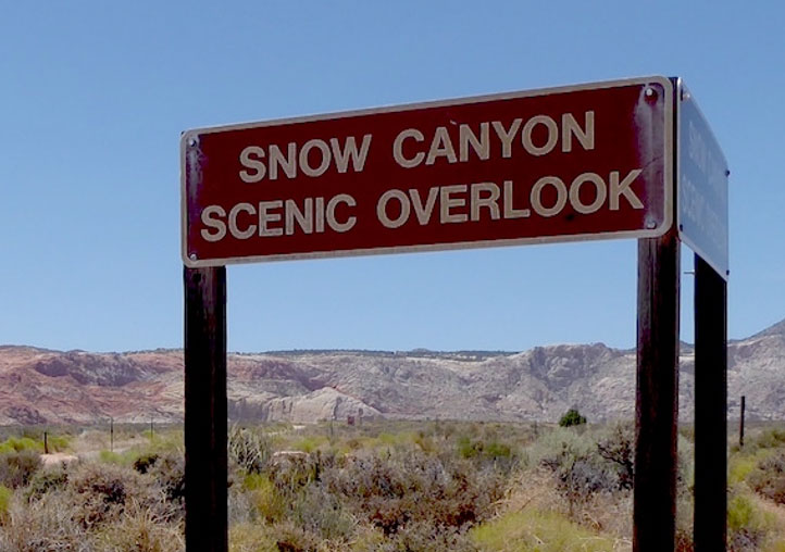
(Scenic Overlook Sign on SR-18)
A short drive of about 1/8 mile off SR-18 provides an overlook of Snow Canyon viewed from the East, prior to entering the Park.
Mile Markers 5 through 11
Hiking and Bicycle Paved Path
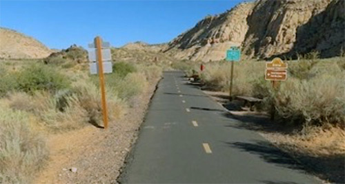
(Bike and Walking Trail)
This path connects the St. George system of bike and hiking paths along SR-18 and back to St. George through Snow Canyon.
Mile Marker 11
Snow Canyon State Park

(Entrance to Snow Canyon State Park Off SR-18)
Snow Canyon offers 16 miles of hiking trails, technical rock climbing, biking, and horseback riding. It features a very nice campground open year-round. People also enjoy nature studies, wildlife viewing, and photographic opportunities galore. The park features a canyon carved from the red and white Navajo sandstone of the Red Mountains, as well as the extinct Santa Clara Volcano, lava tubes, lava flows, and sand dunes.
Mile Marker 11.5
White Rocks Trailhead into Snow Canyon
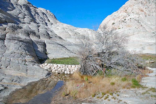
(Amphitheater at White Rocks)
This trailhead is adjacent to SR-18 and a short hike leads into calcium impregnated rocks giving them a white color, and forming an amphitheater.
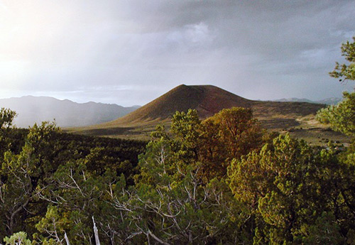
Mile Marker 12.5
Santa Clara Cinder Cone
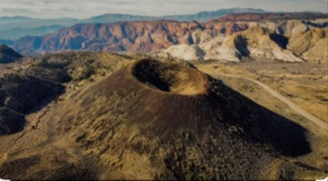
(Santa Clara Cinder Cone)
A number of extinct volcanos border SR-18, forming the Santa Clara volcanic field and lava flow. The Santa Clara Cinder Cone is right along SR-18 as seen in the photo. It is located between Diamond Valley and Snow Canyon State Park (seen behind the cinder cone). The Trailhead is along SR-18 and leads up to the crater.
Mile Marker 13
Santa Clara Volcano
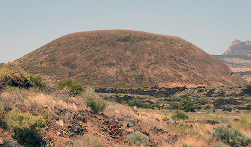
(Santa Clara Volcano)
This is the youngest volcano in Washington County of the Santa Clara Volcanic Field.
Mile Markers 5-20
Mountain Bike, Horseman,
and ATV Fire Trails

(Fire Lanes Afford Off-Road Exploration)
All along the SR-12 corridor, fire trails provide miles of opportunities for on-trail exploration.
Mile Marker 15
Red Mountain Trailhead

(Red Mountain Trailhead)
The Red Mountain Trail is a multi-modal hike and equestrian trail that brings visitors to the north rim of Snow Canyon. The views of the canyon and its multi-colored edges are impressive, which is one reason this trail enjoys its popularity. The trailhead has ample parking for horse trailers and sedans alike. The Snow Canyon Overlook portion of this trail is part of the Red Mountain Trail system and is accessed from just south of Dammeron Valley. This trail is easy to moderate, with some sandy patches. From the overlook you can see all the way through Snow Canyon, past St George, out to the Arizona Strip.
Mile Marker 16
Proposed Laccolith Trail

(Proposed Laccolith Trail Approximate Location
From Dammeron Valley)
Public lands have many intended uses, including recreational enjoyment by residents and visitors. As the SR-18 Scenic Resource Coalition works towards achieving designation of SR-18 as a Utah Scenic Byway, we are also exploring the opportunity to develop a new day-use and overnight-use non-motorized trail from SR-18 to the Western base of the Pine Mountain Laccolith. The trail is intended for use by equestrians and hikers, incorporating designated view locations with educational placards, and seasonal water sources for overnight backpackers.
Mile Marker 17.5
Bold and Delaney Winery
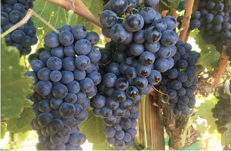
Screenshot
(Bold and Delaney Winery)
The Bold & Delaney Winery is located in Dammeron Valley, Utah. It is situated in the Dammeron Valley Vineyards which were first established on a 5-acre parcel in 2014 and has expanded since to encompass several adjacent parcels. Wines available include: Red Varietals, Red Blends, White Varietals, and White Blends.
Mile Marker 18
Veyo Volcano
(Veyo Volcano)
The Veyo Volcano does not have an established trail, but it is open to visitors. To explore the Veyo Volcano, look for a pullout on the west side of Highway 18 about a mile south of downtown Veyo. Here you will see a gate with a yellow sign asking visitors to close the gate behind them. The gate is held shut with a simple chain and swivel snap; there is no lock.
Mile Marker 18
Road to Sand Cove and Vortex
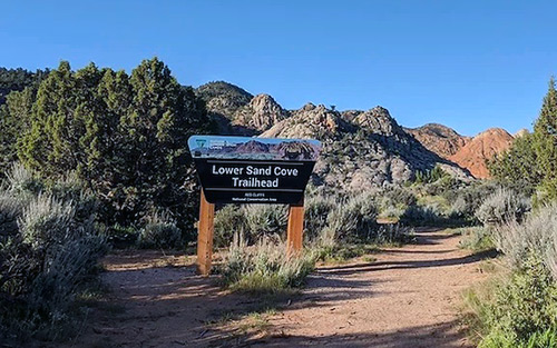
(Lower Sand Cove Trailhead (aka Vortex)
On the South side of the Veyo Volcano, a gravel road leads West. Upper and Lower Sound Cove offer fishing and camping, and parking for hiking to the Vortex, Prophecy Wall, other rock formations, and to Gunlock State Park.
Mile Marker 19.5
Veyo Pool, Canyon Climbing, and Camping
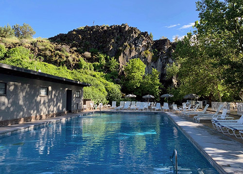
(Veyo Pool)
Swimming, rock climbing, and crawdad catching are among the activities. Veyo Pool has been a local getaway since it was established in the 1920’s. Swim in pristine spring water that’s always the perfect temperature. Veyo Pool Hot Springs offers a large pool filled daily with geothermal mineral water.
Mile Marker 20
Veyo Pies

(Veyo Pies - 30+ Years)
This small-town bakery opened its doors nearly 30 years ago and over the years, it has certainly perfected the pie-making process. While this Utah bakery specializes in pies, it isn’t the only thing on its menu. Veyo Pies also offers a selection of cookies, cinnamon rolls, and various pastries.
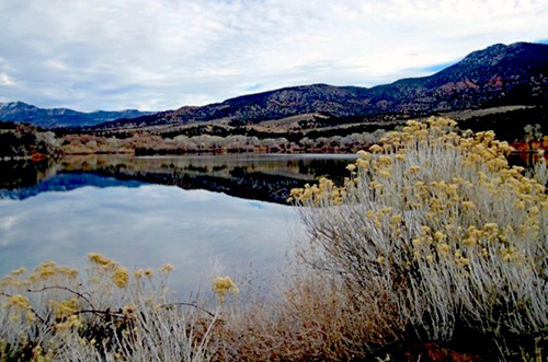
Mile Marker 20
Road to Gunlock State Park
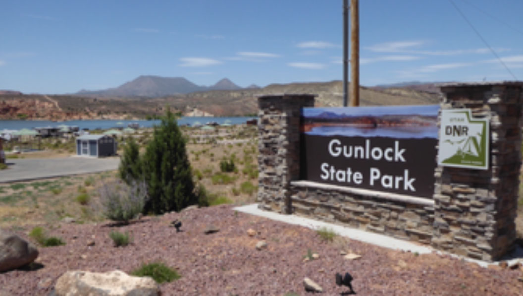
(Gunlock State Park)
Boat, fish, and swim on the tranquil waters at Gunlock Reservoir, or enjoy an afternoon picnic on the beach. Warm waters during summer and a mild winter climate make the park a year-round destination.
Mile Marker 24
Baker Dam Recreation Area
(Baker Dam Sign Off SR-18)
Located at the base of the majestic Pine Valley Mountains, the Baker Dam Reservoir area provides a cool escape from St. George and nearby communities. Managed by the Baker Dam Reservoir Association and stocked with trout by the Utah State Division of Wildlife Resources, it is a popular camping and fishing spot. The Baker Dam Recreation Area is accessible year-round. Baker Dam Recreation Area serves as a great hub for hunters as well as off-highway vehicle enthusiasts exploring higher elevations.
Mile Marker 24
Holmstead Ranch

(Holmstead Ranch)
Passing across Baker Dam and nestled in the shadows of Pine Valley Mountain Holmstead Ranch Resort offers a mixture of adventure and relaxation.
Mile Marker 25
Baker Creek Lavender Farm
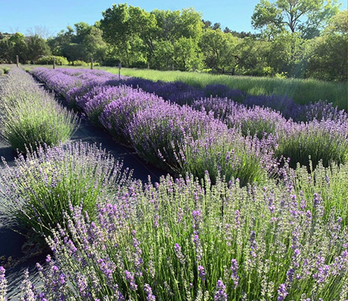
(Baker Creek Lavender Farm)
Baker Creek Lavender Farm is a hidden gem tucked away behind Baker Dam Reservoir. The lavender farm is open for visitors during the lavender bloom season in the summer months. Shop in their store or relax in their meadow.
Mile Marker 25
Mountain Man Rendezvous
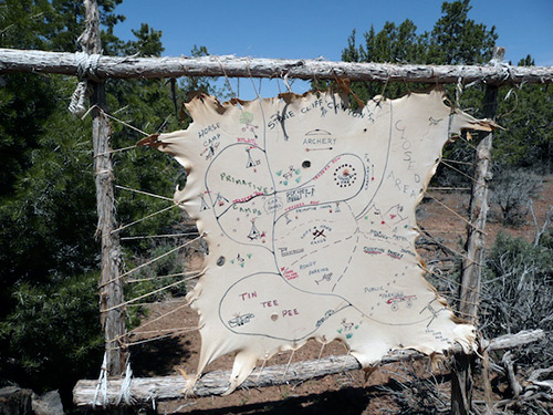
(Rendezvous Map)
Each Spring, Anazazi Free-Trappers promote the use and expertise of tools that were necessary for the survival of our forefathers, who lived and died in the shadow of the Rocky Mountains and braved the danger of The Great Plains during the period of the fur trade. The site (Stone Cliff Canyon) consists of 120 acres at approximately 5000 feet elevation, located at the base of the Pine Valley Mountains and easy access only 1/2 mile from SR-18.
Mile Marker 27
St. George Marathon Start
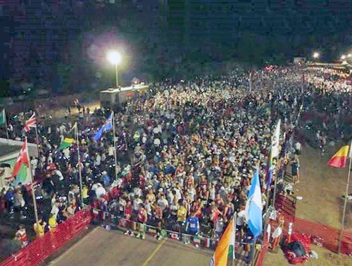
(Start of St. George Marathon In The Dark)
This annual event, starting in Central at Mile Marker 29 and ending in St. George, results in millions of dollars of revenue to St. George and Washington County. Along with the annual Half Iron Man Triathlon and the annual Huntsman Senior Games, other foot and cycling activities have chosen SR-18 because of its scenic beauty and exceptional challenge.
Mile Marker 27
Road to Pine Valley Recreation Area

(Pine Valley Lake)
The Pine Valley Mountains are an attractive small range that rises 10,365 feet surrounded by desert to thick forests of pine and aspen, and to the town of Pine Valley. Its pleasant summer temperatures and heavy forestation provide a welcome respite from the more hot and arid desert. The area has a good network of trails for hiking, horseback riding, lodging, dining, several campgrounds and fishing opportunities.
Mile Marker 30
Mountain Meadows
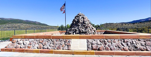
(Monument at Mountain Meadows Massacre)
This area, along SR-18, was a place of rest and grazing used by pack trains and drovers on the Old Spanish Trail and later by Mormons, Forty-niners, mail riders, migrants and teamsters on the Mormon Road on their way overland between Utah and California. This became the site of what is referred to as the Mountain Meadows Massacre. In September 1857, a branch of territorial militia in southern Utah composed entirely of Latter-day Saints, along with some American Indians they recruited, laid siege to a wagon train of emigrants traveling from Arkansas to California. The militiamen carried out a deliberate massacre, killing 120 men, women, and children in this valley known as Mountain Meadow.
Mile Marker 30
Old Spanish Trail
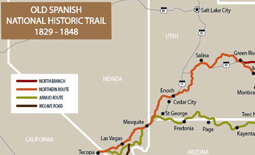
(Old Spanish Trail Crosses SR-18)
It was here, at Mountain Meadows, that the Old Spanish Trail crossed the current SR-18.
Mile Marker 40
Enterprise, Utah
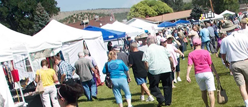
(Enterprise Corn Fest Festival)
Enterprise is a rural farming community located in south west Utah. They say the area raises some of the best hay, corn and kids. At the end of August, Enterprise City hosts its annual “Corn Fest”, where the whole town turns out to celebrate small town life and the bounty that local farmers produce.
Mile Marker 40
Enterprise Reservoirs
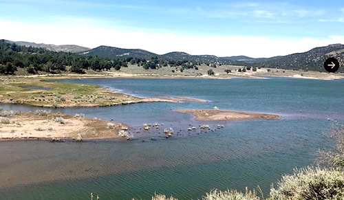
(Enterprise Reservoirs)
The Enterprise Reservoirs lie within a pinyon-juniper forest surrounded by large volcanic tuff rocks. The reservoirs are popular for fishing, boating, kayaking and canoeing, and wildlife viewing. Nearby opportunities include OHV riding, hiking, biking, horseback riding, campground and dispersed camping.
Summer Rodeo Events
Gunlock / Veyo / Enterprise
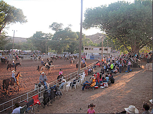
(Gunlock Rodeo)
During the summer months, small-town rodeos are held in the above-named communities. Check locally for dates.
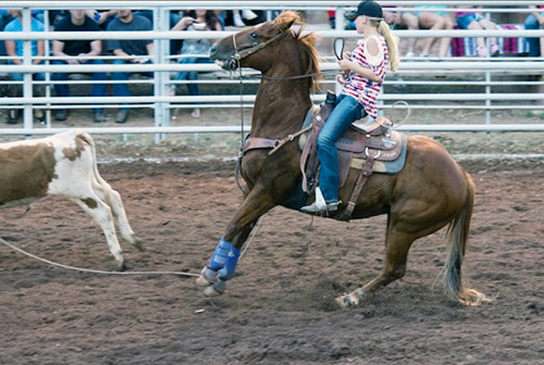
(Veyo Rodeo)
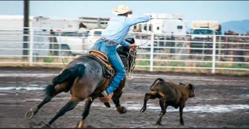
(Enterprise Rodeo)